There are many reasons why the Parque Nacional de Monfragüe is so alluring. It’s one of the most representative areas of Mediterranean forest and scrubland and a perfect place for gazing up at the sky and contemplating the birds of prey above. Hiking enthusiasts will be in their element here, though anyone looking to get closer to nature will enjoy a visit to this 18,000-hectare national park.
It’s situated in the north of the province of Cáceres, between Navalmoral de la Mata, Plasencia and Trujillo. Humans have lived here for thousands of years and the name of the park dates back to the Romans. They named the area ‘Mons Fragorum’ (which roughly translates as ‘Dense Mountain’). It was the Romans who built the first castles and watchtowers, and their famous Roman roads were later restored by transhumant livestock farmers.
A natural paradise in Extremadura
The Parque de Monfragüe is an outstanding area of natural beauty in Extremadura. It achieved Natural Park status in 1979 and in 1988 was deemed a Special Protection Area for birds. In 2003 it became a UNESCO Biosphere Reserve and in 2007 was finally named a National Park – one of fifteen in Spain.
The Tajo and Tiétar rivers both flow through the park between boulders and canyons, providing a habitat for nesting birds. The park is home to more than 280 species of vertebrate, many of which are threatened with extinction. Keep a look out for the Spanish imperial eagle, cinereous vulture, black stork and lynx.
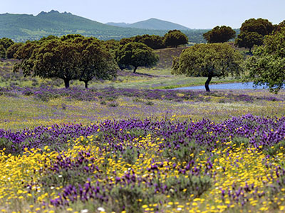
The park is an outstanding example of Mediterranean forest and scrubland, where wet shady zones contrast with sunny spots. Trails will take you through cork and holm oak, rockrose, strawberry tree, heather, laurustine, ash, willow and holly.
What to see in Monfragüe: cave paintings, birds of prey and much more
Monfragüe has many treasures in store for the avid explorer and caters to a variety of interests. Regardless, we recommend stopping in first at the interpretation and visitor centre to get to know the area a little better. You’ll find it in the small village of Villarreal de San Carlos, which is in the park itself.
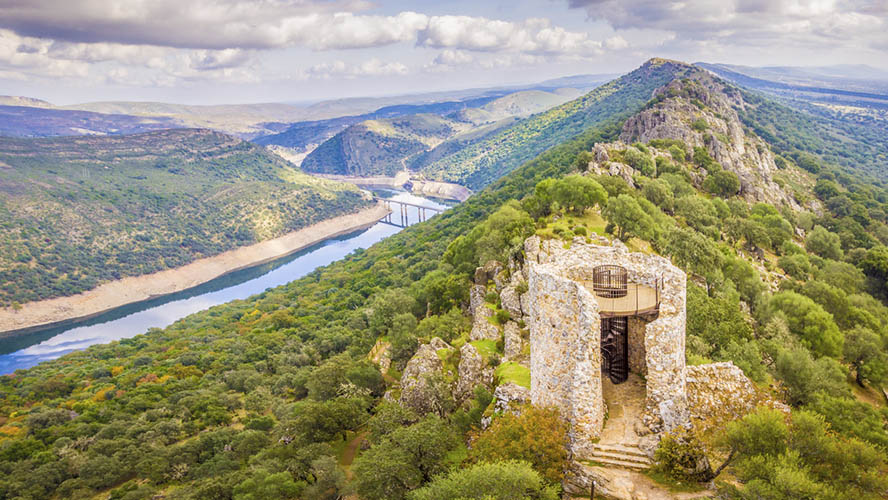
Among the park’s must-see places are the Castillo de Monfragüe, built by the Arabs in the 9th century. The views from this strategic fortress stretch over miles and miles of wild country. Two towers are still standing, as well as some fragments of the walls, the barbican and a water tank.
The Cueva del Castillo complete with cave paintings is another special place. It’s closed to the public to protect what’s inside, so you’ll only be able to see the outermost area. To check out replicas of the paintings, head to the Centro de Arte Rupestre in Torrejón el Rubio, near the southern gateway into the park. This visitor centre has extensive information on the subject.
The park also has an observatory with a 4-metre dome. Up to ten people can visit at a time. The telescopes at the Observatorio Astronómico de Monfragüe have amazing views of the unobscured skies above. Contact the tourism office for Torrejón el Rubio to arrange a visit.
Villarreal de San Carlos, the only settlement in Monfragüe
Villarreal de San Carlos is the only populated area in the Parque Nacional de Monfragüe. This tiny village is part of the municipality of Serradilla and was founded by Charles III in the 18th century. It served as a garrison from which to patrol the Monfragüe area. The hiking trail called the Cañada Real Trujillana, between Trujillo and Plasencia, goes through this zone. Back in the day, the region was often targeted by bandits who attacked walkers, livestock farmers and traders between Puente del Cardenal and Puerto de La Serrana.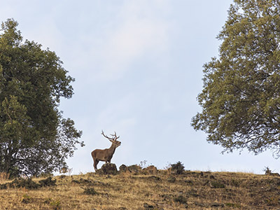
Villarreal de San Carlos was always a place for travellers and had fountains providing water for local residents, though the village never grew very big. Its one single street makes it a peaceful place amid impressive natural surroundings. Visitors to the area can find accommodation in one of several casas rurales or country houses. The village has a tiny church dedicated to the Virgen del Socorro (Our Lady of Succour), as well as the interpretation centre for the national park.
Salto del Gitano and other viewpoints
If you’re into birdwatching, you’ll need to know the location of the various viewpoints in the park. Views aside, they’re the perfect vantage point from which to observe griffon vulture, cinereous vulture and Spanish imperial eagle, among other species. In fact, this is one of Spain’s prime ornithological areas.
The most famous viewpoint in the park is the Salto del Gitano, overlooking beautiful cliffs next to the River Tagus. Large numbers of birds are found here, and you’ll almost certainly spot griffon vultures soaring overhead.
The Castillo de Monfragüe viewpoint has several observation platforms with breathtaking panoramas, and from the Pliegue viewpoint you can contemplate the twists and turns of the River Tiétar. This area also has fascinating Caradoc quartz formations.
The viewpoint called La Malavuelta provides a different perspective over the River Tiétar and the Tajadilla Canyon. From La Báscula, as well as birdwatching you may be lucky enough to see the rutting of the deer (September and October).
Other options are:
- La Higuerilla: Great for observing water birds such as heron and cormorant.
- La Tajadilla: Just a few metres from the damn at the Torrejón-Tiétar reservoir. It’s a nice picnic spot.
- La Serrana and Portilla del Tiétar: The latter is ideal for spotting griffon vulture and Spanish imperial eagle.
Waymarked trails in the Parque Nacional de Monfragüe
Monfragüe is a hiker’s paradise (link: hiking in Extremadura). The park extends across a geological fold more than 30 km long and 7 km wide, making a total surface area of 18,000 hectares. It has four main hiking routes, all waymarked and catering to different levels. The trails are graded Red, blue, yellow or green.
The green and yellow trails are the easiest. The first is a pretty and relatively simple circular route of little more than 7 km. It starts in Villarreal de San Carlos and takes you past the peak called Gimio. The yellow trail is around 9 km, starting in Villareal and stretching to the Torrejón reservoir. It takes you along the northern banks of the Tiétar and comes to and end at La Tajadilla viewpoint, passing by the Alisar and Tres Caños fountains.
The red route takes in the Castillo de Monfragüe, the Salto del Gitano viewpoint and the Parra fountain, over a distance of 16 km. This medium-difficulty trail is split into independent sections.
The blue route follows the path of the Cañada Real Trujillana trail and links Villarreal de San Carlos with Malpartida de Cáceres. It’s around 19 km long and is also medium difficulty.
Check out our destination guides for more information about what to see and do in Extremadura.