
Southern district
Seville’s southern district, made up of 14 neighbourhoods and 75,600 residents, is one of the largest in the city. This extremely varied expanse, which houses opposing urban and social realities, stretches from the popular Plaza de España tourist site to the poorer area known as Las tres mil viviendas.
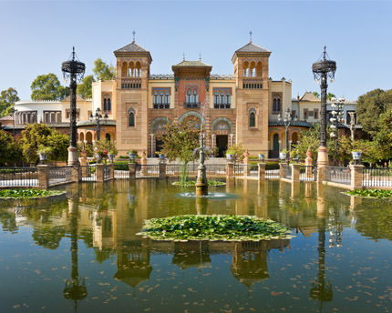
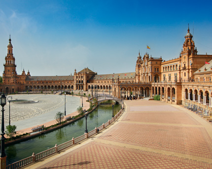
The biggest tourist attractions are located in the Prado-Parque María Luisa neighbourhood, which is adjacent to the old quarter. The district covers most of the land used for Seville’s Ibero-American Exposition held in 1929, and includes the lovely María Luisa Park. This Cultural Heritage Site opened in 1914 and is one of the city’s green areas. It houses Plaza de España, an enormous construction that locals are extremely proud of. Designed by the architect Aníbal González, it served as the main pavilion for the Ibero-American Exposition. With its imperial appearance—the semicircle is 170 metres in diameter—the square was added to the Treasures of European Film Culture after appearing in films such as Lawrence of Arabia and Star Wars Episode II: Attack of the Clones. The exposition’s original pavilions now house the interesting Seville Archaeology Museum and its Roman, Moorish and Tartessian relics, as well as the Museum of Arts and Popular Customs of Seville.
The El Porvenir neighbourhood, erected in the 1920s, offers an interesting combination of industrial buildings and numerous villas—detached homes with a garden—designed by the city’s leading architects of that era. Examples include the Torre del Agua [Water Tower] (now the neighbourhood’s civic centre), the La Coromina factory (now the University of Seville’s administration building) and the La Catalana de Gas factory. Other noteworthy landmarks are the San Sebastián Gothic-Mudejar church and the former Engineers barracks, dating back to 1901.
Next up is the Bami neighbourhood, which was built in parallel to the construction of the Virgen del Rocío University Hospital in the 1950s. In fact, its name is the acronym for Banco Mercantil Industrial, the real estate developer that built this area for its construction workers. Just like other neighbourhoods in the district, such as El Plantinar, it has become popular with students in light of its affordable prices and proximity to the campus.
Also linked to the Southern District (although administratively it forms part of the Bellavista-La Palmera district), we must also mention Avenida de La Palmera, a wide avenue created for the 1929 World Fair. Lined with historic pavilions, villas and palaces, throughout the twentieth century it served as Seville’s southern entrance. The avenue begins at María Luisa Park and ends at Benito Villamarín, the Betis football club’s stadium.
Lastly, the southernmost neighbourhoods of Las Letanías, Polígono Sur and Oliva form part of Las tres mil viviendas. Comprised of blocks of flats that were built in the 1970s, this area is considered to be Seville’s most dangerous poor neighbourhood. Due to the overall deterioration and lack of basic services, this area has gained a reputation as an example of ‘vertical slums’.
Nearby plans
Related plans
Plaza de España, Seville’s embrace to visitors
Seville’s Plaza de España, the main building constructed for the Ibero-American Exposition of 1929, symbolises the embrace between Spain and its former colonies.

María Luisa Park: romantic nature
Since the late nineteenth century, María Luisa Park, with its hundreds of species of plants, has been one of the most romantic places in Seville.
Qué ver en Sevilla: Los 17 lugares imprescindibles
Sevilla no tiene un color especial, sino mil tonos, sabores y olores para disfrutar. Aquí os presentamos una lista de los lugares imprescindibles.